Showing posts with label state park campground. Show all posts

Sunday, September 18, 2011

Prineville to Unity Lake State Park, OR

We didn't take any photos yesterday of the campground, so I took photos while Mike was breaking camp.

From Prineville to Unity Lake State Park, OR

We stopped at the Shell gas station in Prineville and got gas in the RV ($3.899 gal). On our way out of town we passed by the Crook County Courthouse.

From Prineville to Unity Lake State Park, OR

The terrain changed from prairie

From Prineville to Unity Lake State Park, OR

to mountains.

From Prineville to Unity Lake State Park, OR

We drove through Picture Gorge (here's a short movie)

From Prineville to Unity Lake State Park, OR

and then back on to prairies and farms.

From Prineville to Unity Lake State Park, OR

We drove through the town of Dayville and took a photo of the post office there that had been a stop for the Pony Express.

From Prineville to Unity Lake State Park, OR

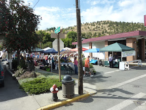
We next drove through the town of John Day and passed by the Saturday Farmers' Market.


From Prineville to Unity Lake State Park, OR

There are towns named Dayville and John Day, the John Day River and the John Day Fossil Beds National Monument named after the early frontiersman John Day.

When we were about 2 miles west of the town of Unity, we turned north onto SR-245 and drove about 2 miles out to the Unity Lake State Park.

From Prineville to Unity Lake State Park, OR

From Prineville to Unity Lake State Park, OR

We arrived at the campground around 12:30 after driving 167 miles from Prineville. We chose campsite #17 which is a pull-through and parked the RV. We filled out a registration form and wrote a check for $22 for 1 night's stay.

From Prineville to Unity Lake State Park, OR

After we leveled the RV and put out the slides, I fixed lunch. There are several RVs here and there is a group of people having a family reunion here this weekend.

We have electric (30 amp) and water hook-ups and we're on a paved pad that is level and grass on both sides of the RV - Tinker REALLY appreciates that.

We are able to see Unity Lake from our RV.

From Prineville to Unity Lake State Park, OR

The state park is a pleasant break after driving through the high desert that we've seen most of today.

Thursday, September 15, 2011

Western Antique Aeroplane & Automobile Museum

We both slept well last night and the traffic noise from I-84 didn’t bother us. This morning after breakfast we walked around the campground and took photos. It’s still windy and pleasantly cool.

After lunch we drove west to Hood River to visit the Western Antique Aeroplane and Automobile Museum – WAAAM.

From Western Antique Aeroplane & Automobile Museum 1

We were greeted by museum volunteers Perry and Don.

From Western Antique Aeroplane & Automobile Museum 1

We paid the $10 each (senior tickets) and were given a diagram of the museum. We walked through a door into the first display area called Hangar M1 which covers pre-WW II and is 37,500 square feet.

From Western Antique Aeroplane & Automobile Museum 1

There were antique tractors, automobiles and airplanes. This is a photo of just ONE row of antique autos.

From Western Antique Aeroplane & Automobile Museum 1

The best way to describe Hangar M1 is WOW! I’ll just let the photos Mike took speak for themselves.

From Western Antique Aeroplane & Automobile Museum 1

We saw these 2 airplanes that had appeared in the movie "The Tarnished Angles" with Rock Hudson, Robert Taylor and Dorothy Malone.

From Western Antique Aeroplane & Automobile Museum 2


From Western Antique Aeroplane & Automobile Museum 2

There was a small section devoted to women aviators.

From Western Antique Aeroplane & Automobile Museum 2

We next went into Hangar M2 which contains vehicles from WW II and later and is 45,000 square feet. Again another WOW!

From Western Antique Aeroplane & Automobile Museum 1

There were classic autos, more motorcycles, military vehicles and airplanes and a play area for children with a motorcycle and helicopter for them to get on.

From Western Antique Aeroplane & Automobile Museum 1

He took so many photos that I’ve divided them into 2 web albums – one album for autos, motorcycles and other vehicles, and one album for airplanes.

I am so glad that I picked up a brochure for the museum at the campground last night. We wouldn’t have known about it and we would have missed a great museum.

We even had a good view of Mt. Hood from the museum. We learned that there is a huge forest fire near Mt. Hood and that is smoke not haze that we see.

We drove through the downtown are of Hood River and it is very attractive and a LOT of coffee shops.

Wednesday, September 14, 2011

Along the Columbia River to Memaloose State Park

We set the alarm clock last night for 7 a.m. so we could get an early start today even though we only had about 200 miles to drive. It was cloudy and in the low 60's this morning.

I think I forgot to mention in an earlier post that we had to check out a Comcast Digital Transport Adapter in order to receive all of the cable channels at Ft. Lewis RV Park. We do have a digital converter for the local antenna, but this is different from that. So while Mike was driving the RV to where we could hook up the car, I went to the campground office to turn the adapter in.

This was our first time hitching up the car with our new Roadmaster All Terrain Tow Bar and all went well. We left the campground at 9:16 and headed south on I-5. We made a quick stop at a rest area near Maytown and while I walked Tinker, Mike did his walk-around the RV and car.

From Ft. Lewis to Memaloose State Park

We stopped at 11:30 for an early lunch at a rest area about 12 miles north of Vancouver. Shortly after leaving the rest area, we connected with I-205 south and crossed the Columbia River into Oregon at 12:15.

From Ft. Lewis to Memaloose State Park

Shortly after entering Oregon we exited I-205 to I-84 east along the Columbia River. It had been cloudy and in the low 60's most of today, so we weren't able to see the tops of the mountains.

From Ft. Lewis to Memaloose State Park

A little before 1:00 the sun came out and the haze cleared up. We passed by the Bonneville Dam on the Columbia River and this is all we got to see of it.

From Ft. Lewis to Memaloose State Park

Eventually I-84 was close enough to get some great views of the Columbia River.

From Ft. Lewis to Memaloose State Park

The Memaloose State Park is located on the Columbia River 10 miles west of The Dalles. The only way to get to Memaloose State Park is through the rest area located on the north side of I-84.

From Ft. Lewis to Memaloose State Park


We exited I-84 East at exit 76 and got back on I-84 heading west for 3 miles to the rest area. We drove through the rest area to the entrance to Memaloose State Park.

From Ft. Lewis to Memaloose State Park

We located our campsite and stopped to disconnect the Vue. Mike then backed the motorhome into our campsite. We are in site #A-13 with full hook-ups (30 amp elec).

It is so windy here that Mike set up our portable satellite dish (the one on the rooftop would "flop" in the wind and we would lose our signal). After setting up the RV and watching a little TV, we all ended up taking a nap - Tinker on the sofa with  me and Mike in the recliner.

Our campsite backs up next to I-84 and there is a lot of traffic noise, but it didn't seem to bother our naps and I doubt it'll keep us awake tonight.

We didn't get any photos of our campsite this afternoon, we'll do that in the morning. We're going to be here for

Saturday, July 2, 2011

Byers Lake Campground

We said goodbye this morning to Ron & Cindi. They are going down to Palmer and then on to Valdez before they head back home to Florida. We really enjoyed spending last evening with them and had a fun time.

We didn’t take any photos yesterday of the campground, so Mike took some this morning.

From Denali State Park

From Denali State Park

This afternoon we took Tinker and drove over to the Alaska Veterans Memorial which is next to the entrance to the campground. There are 5 20-foot tall concrete panels for each of the services and they give the history of each service in Alaska.

From Denali State Park

From Denali State Park

There are also displays honoring Congressional Medal of Honor recipients with connections to Alaska.

From Denali State Park

There was an information display showing the history of helicopter rescues on Mt. McKinley.

From Denali State Park

After returning to the campground, we took Tinker for a “hike” on part of the Byers Lake Loop Trail. There are a lot of mosquitoes here and we put on mosquito repellent before setting out on our walk.

From Denali State Park

From Denali State Park

We rounded a corner on the trail and came across this woman who had found a quite place to read a book by the lake.

From Denali State Park

Then we saw a woman in a kayak who had gotten caught on some rocks by the trail and Mike helped her get loose.

From Denali State Park

We continued on the trail around the lake until we came across this old homesteader’s cabin.

From Denali State Park

Then we decided to go back to the RV and followed a trail up the hill from the lake and then connected with a trail that took us back to the campground.

From Denali State Park

Because this is the 4th of July weekend the campground is starting to fill up and I’m sure there will be more arrivals tomorrow. We are leaving here in the morning and heading down to Anchorage. We are planning on staying at Elmendorf Air Force Base FamCamp. They don’t take reservations, so we will have to see what is available when we get there.

We haven’t had cell phone service since we left Cantwell yesterday and are looking forward to being in Anchorage. We don’t know how long we’ll stay in Anchorage – at least a week maybe two.

Friday, July 1, 2011

Cantwell to Denali State Park

We left Cantwell RV Park this morning at 9:20 and stopped at the Tesora gas station near the campground to get gas in the RV. We got 41.839 gallons at $4.589 a gallon. Just as we were pulling out of the gas station we saw our friends, Ron & Cindi pull into the gas station.

We waited while Ron got gas in his truck and then we all drove down to Denali View North Campground in the Denali State Park. This is a large paved parking lot with spaces for RVs (no hook-ups) with fire pits and picnic tables. There is a camp host there and it costs $10 to camp there.

From Cantwell to Denali State Park

From Cantwell to Denali State Park

We were hoping to be able to see Mt. McKinley from there, but it was too cloudy. We did see this World War II memorial for the crew and passengers who died in a C-47 that crashed on Mt. Deception September 18, 1944.

From Cantwell to Denali State Park

Ron & Cindi had thought about camping there for tonight, but decided to come down to Byers Lake Campground where we are going to stay.

At 11:30 we passed the Alaska Veterans Memorial which was 15 miles south of Denali View North and began to look for the entrance to Byers Lake Campground. The sign was set so far back from the road and partially hidden by bushes, that we didn’t see the sign until we were even with the entrance. Ron & Cindi were ahead of us and they missed the sign, too. Mike called Ron on our CB and told him we had missed the road into the campground.

Ron & Cindi had to drive up the highway until they could find a place to turn around with their 5th wheel. We parked on the side of the road & unhitched the car. Then Mike was able to back up the motorhome down the road far enough so he could turn into the entrance road to the campground.

Byers Lake Campground is a self-registration campground. We drove down to D Loop and began to look for campsites. Ron got in the car with me and we drove around D & C Loops looking for campsites we both could fit in and decided that the 2 we were considering on D Loop were the best fit.

We are in site #6 (a pull-through site) and Ron & Cindi are across from us in site #5 (a back-in site). After getting our RVs set up, Mike & Ron went down to the registration kiosk in our car to pay for our stay here. Ron & Cindi are just staying here for tonight and we will be here for 2 nights. There are no hook-ups here in the campground and the fee is $10 a night. We had driven 63 miles today from Cantwell to Byers Lake.

After dinner Cindi & Ron came over and we spent the evening visiting and playing a game of Mexican Train Dominoes – the long game.

From Denali State Park

We had a great time and didn’t realize that it was after 11 p.m. Since Ron & Cindi are planning on leaving tomorrow morning around 8:30, we called it a night and said goodbye in case Mike & I aren't awake in the morning when they leave.

Thursday, May 26, 2011

Cherry Creek State Park

Tinker is still adjusting to Mountain Time - he wanted us to get up at 6:00 this morning - not happening! We did get up a little after 7:00 and it was 46°. We even ran the heat a little last night and had our electric blanket on.

This morning I called Dish Network this morning to have our location changed so our programs come on in the correct time zone and spent 50 minutes on the phone. Apparently because we are in the Denver area, we are supposed to receive local networks even though we get network channels through All American Direct. So the customer service rep had to check with someone and found out we didn't have to get the Denver stations. Our account is listed as a residential account and it needs to be changed to a RV account. I was also told that we need to fax in our vehicle registration for the RV every year to maintain our status as a RV account. Long story short - our programs are now showing in Mountain Time and we have 30 days to fax in our RV registration to Dish Network. I can hardly wait until I have to call them again to change our location so our shows come on in the same time zone as the one we're in!

By the time I finished my call to Dish Network, it was time to take Tinker to a Petsmart near the state park this morning for his 10:00 appointment for a bath. Afterwards we stopped by Wal-Mart Supercenter to get a few groceries before heading back to the RV. While we were at Wal-Mart I took this photo of Mt. Evans. It is about 45 miles from Aurora and is 14,264 feet high.

From Colorado

Then I took this photo of Mt. Evans at the state park on the way back to the RV. Just beautiful!

From Colorado

 I had just started to fix lunch when Petsmart called to say that Tinker was ready to be picked up. We ate lunch before leaving to get Tinker and stopped at the Home Depot near Petsmart to get a couple of items before we got Tinker at Petsmart.

From Colorado

We stopped by the new laundromat here in the campground to see when it would be ready and they were waiting on the gas to be connected for the dryers this afternoon. Guess what I'm doing in the morning? They have 3 washers & 3 dryers and I have more than 3 loads, so I'll be there a while.

I spent the rest of the day updating our expenses in Quicken, paying a few bills and catching up on some stuff.

Mike replaced the elevation sensor for our rooftop satellite. He had ordered a refurbished elevation sensor kit and it was in the mail we picked up yesterday. He went up on the roof and replaced the elevation sensor and then installed the LED readout plate. We cranked the satellite dish up and tuned in our satellite and it worked fine. But we switched back to the portable dish, because the wind was blowing enough to make the rooftop dish wobble and lose the signal.

Mike did take photos of the campground this afternoon. There are more people coming into the campground and I'm sure it will be full by this weekend.

From Colorado

From Colorado