Showing posts with label Yukon Territory. Show all posts

Monday, June 20, 2011

Whitehorse to Kluane Lake

It was 48° with a light rain when we got up this morning. Before leaving the campground, Mike called campgrounds in Destruction Bay, Tok, and Fairbanks to make reservations for the times we will be there.

We left Pioneer RV Park at 9:45 and drove west on Hwy 1. Just north of Whitehorse we passed by the Yukon Beringia Interpretive Centre (which we didn’t get to visit)

From Whitehorse

and the World’s Largest Weather Vane.

From Whitehorse

About 30 minutes from Whitehorse we came across this 14 mile section of gravel road and had to slow down to 14 mph.

From Whitehorse to Kluane Lake

We stopped for lunch at noon at a rest area about 6 miles before we reached Haines Junction. The highway turned to the north at Haines Junction. It was still very overcast and the clouds were staying low on the mountains.

From Whitehorse to Kluane Lake

From Whitehorse to Kluane Lake

Every so often we would pass a pull-off where someone had parked their RV and were dry camping. In Canada you can park and spend the night at rest areas and pull-offs if there is no sign saying no overnight parking or camping.

From Whitehorse to Kluane Lake

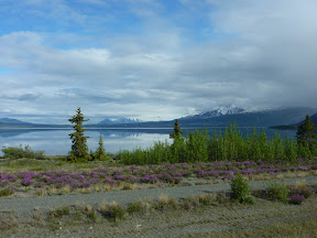
We had intended to spend the night at a campground in Destruction Bay, but a little before 2 p.m. we saw this pull-off alongside the Kluane Lake. There were a few other RVs parked there and we decided to spend the night here. We had only driven 153 miles since leaving Whitehorse
and it was a little before 2:00, but this was too great a spot to pass up!

From Whitehorse to Kluane Lake

After we parked the RV and got settled for the night, Mike took Tinker out for a walk and some of the plants had tiny little stickers in them. We spent an hour picking the stickers out of Tinker’s hair – he was just covered with them.

From Whitehorse to Kluane Lake

The other RVs that were parked here when we arrived left after a while, but later on this evening a motorhome stopped and then 4 camper vans pulled in to spend the night.

From Whitehorse to Kluane Lake

Just before 7 p.m. I saw this rainbow over the lake and the more the sun came through the clouds, the more vibrant the rainbow became.

From Whitehorse to Kluane Lake

From Whitehorse to Kluane Lake

We couldn’t have asked for a better view or a place to spend the night! And it’s free!
From Whitehorse to Kluane Lake

From Whitehorse to Kluane Lake

Sunday, June 19, 2011

Visit to the S.S. Klondike & RV windshield repaired

This morning George from Glass Magnum came to the campground to repair a couple of rock dings in our RV windshield. We saw him last night repairing a windshield in an RV and arranged for him come to the RV park to repair our windshield.  George found a 3rd place in the windshield that needed to be repaired and it cost us $135 US to repair the 3 dings & he did a great job. Before George had finished with our windshield, a couple more people in the RV park talked with him about repairing their windshields.

.After lunch we drove into Whitehorse to tour the sternwheeler, S.S. Klondike. We paid $6.05 CAD each to go on the guided tour.


From S.S. Klondike

The S.S. Klondike was built in Whitehorse in 1929 by the British Yukon Navigation Company and operated between Whitehorse and Stewart Landing and later to Dawson City. She would take passengers & freight from Dawson City and silver-lead ore from the Mayo Mining District to Whitehorse. The ore would then be transferred to rail cars to go to Skagway.

In 1936 the S.S. Klondike sank in the Yukon River and the S.S. Klondike II (a carbon copy of the original) was built to continue between Whitehorse and Dawson City. In later years she became mainly a passenger ship until 1955. In 1966 she was moved from the Whitehorse Shipyards to her present site. Because she was so tall and could not pass under the bridge over the Yukon River to her present location, the S.S. Klondike was moved through the town of Whitehorse.

From S.S. Klondike

Maureen was our guide for the S.S. Klondike and she was very knowledgeable about the steamship.

She explained the operation of the steam boiler

From S.S. Klondike

and the steam engine.

From S.S. Klondike

We saw displays of the types of cargo the ship carried. I especially liked seeing this box of explosives surrounded by boxes of gasoline!

From S.S. Klondike

We learned about the accommodations for the 1st and 2nd class passengers and the crew.

From S.S. Klondike

From S.S. Klondike

From S.S. Klondike

The last stop of the tour was up to the pilot house. I stayed down on the cabin deck (the stairs up to the pilot house were more ladder than stairs) while Mike went up to the pilot house.

From S.S. Klondike

After our tour of the S.S. Klondike we stopped at the Visitor's Centre to check on the status and condition of the roads north of here.

Several people in the campground told us they had checked with the Visitor Centre and were told that because of road repairs on the Alaska Highway the driving conditions weren't too good; so they were going up to Dawson City to take the Top of the World Highway and then the Taylor Highway down to Chicken and then south to the Alaska Highway. That route from Dawson City through Chicken and south is about 160 miles with 45 of those miles on gravel & dirt.

When we asked about the road conditions on the Alaska Highway we were told that the conditions were good even with some road repairs being done. We're going to stick with our original plans and continue west on the Alaska Highway tomorrow.

Before returning to the campground we stopped at the Real Canadian Superstore (similar to Wal-Mart Supercenter) to stock up on some groceries.

Saturday, June 18, 2011

Watson Lake to Whitehorse

We left Watson Lake this morning at 8:30 and continued north on Highway 1.

From Watson Lake to Whitehorse

From Watson Lake to Whitehorse

We stopped for lunch at 11:15 at a rest area about 5 miles south of the Yukon Territory border.
We had just finished eating lunch when 2 RVs pulled into the rest area in front of us. We thought that the Denali 5th wheel looked familiar and it was Ron & Cindi from Sebastian, FL. We first met them when they were looking for a campsite at Glacier National Park. They were now traveling with a couple they had met along the way who are also from Florida.

Ron & Cindi are spending tonight in Teslin which is about 20 miles north of the rest area. We told them we were going on up to Whitehorse today. We spent a few minutes catching up on each other's news. It didn't take long for the mosquitoes to find us, so we cut our visit short and got back on the road. I'm sure we'll see Ron & Cindi again somewhere along the way.

We crossed the Morley River about 10 miles south of Teslin. The bridge was being repaired and there was only 1 lane of traffic across the bridge.

From Watson Lake to Whitehorse

We arrived at Pioneer RV Park at 2:30. I went in to the campground office to register while Mike got gas in the RV. We got 150.897 liters at $1.325 Ltr (price after 3¢ a liter discount) or 39.87 gallons at $5.10 a gallon.

From Whitehorse

We are in site #69 which is a pull-through with full hook-ups (30 amp electric). We also have cable TV and wi-fi. This is another campground that is a large parking lot with RV hook-ups. We paid $56.70 CAD or $57.67 US for 2 nights here at the campground.

From Whitehorse

After we got settled in at the campground, we drove into Whitehorse. We stopped at a roadside park to take some photos of the Yukon River and Whitehorse.

From Whitehorse

From Whitehorse

While we were there a woman stopped to talk with us after she saw our Florida car tag. Just as we started to leave, she came running back to ask if we had seen the bald eagle's nest there. We had missed seeing it and thanked her for pointing it out. One of the parents was guarding the nest, but we weren't able to see the chicks.

From Whitehorse

We stopped at the Yukon Visitor Centre to pick up some brochures on the area.

From Whitehorse

Afterwards we drove around Whitehorse taking photos of the town.

From Whitehorse

From Whitehorse

From Whitehorse

From Whitehorse

By now it was dinner time and we stopped at Boston Pizza before heading back to the RV. Mike had the Smokey Mountain Spaghetti and Meatballs and I had a small Meateor pizza and we each had a couple of Rick's Red beers. Our bill came to $53.24 CAD.

Friday, June 17, 2011

Watson Lake & the Sign Post Forest

We arrived at the Watson Lake Tags Gas Station & RV Park at 11:15. We needed gas in the RV, so Mike pumped gas while I went inside the store to register. Since we're also camping here for the night, we got a 2¢ a liter discount on our gas purchase. We got 197.224 liters at $1.349 CAD (after discount price) a liter ($266.06 CAD) which works out to 52.12 gallons at $5.159 a gallon $268.88 US).

From Watson Lake

Our campsite cost $26.25 CAD ($26.52 US) for the night. Since we weren't assigned a specific campsite, we could just pick one & hook up. We chose site #8. We have full hook-ups with 30 amp electric and wi-fi. The "campground" is actually a large parking lot behind the convenience store and gas station.

From Watson Lake

After setting up the RV and eating lunch, we walked across the street to the Sign Post Forest. The Sign Post Forest was started by U.S. Army G.I. Carl K. Lindley, who was working on the Alaska Highway with the 341st Engineers. He was from Danville, IL and homesick, so he erected a sign pointing the way home and showing the mileage to his hometown. Since then others have visited and hung signs here, so that there are now over 70,000 signs in the Sign Post Forest.

From Watson Lake

Several years ago in an antique store we had bought a vehicle registration tag from Camp Rucker which dates from 1942-1955 when the name was changed to Fort Rucker. When we were planning this trip to Alaska, Mike said he had the perfect sign to put up at Watson Lake - the one from Camp Rucker.

We found a post to hang our sign on and Mike used his portable drill to attach it.

From Watson Lake

From Watson Lake

There are so many signs here that it is impossible to read them all.

From Watson Lake

We did find some signs from familiar places.

From Watson Lake

From Watson Lake

We stopped in at the Watson Lake Visitor Center to buy post cards of the Sign Post Forest, but they didn't have any. They said that the campground office should have some post cards, but they didn't have any. We took Tinker back to the RV and then walked down to Hougen's Department Store and we found post cards there. We bought a Pepsi at the coffee shop next door and sat outside to write out our post cards.

From Watson Lake

We've had more RVs come in here at the campground to spend the night and it looks like we might have some rain tonight. Since we don't have any cable here, we'll be watching movies on DVD tonight.


Thursday, June 16, 2011

Coal River to Watson Lake

We left Coal River at 9:15 and headed north to Watson Lake in the Yukon Territory.

We hadn't traveled very far when we saw a bison

From Coal River to Watson Lake

and a little farther on we startled a couple of moose alongside the highway. Fortunately they ran away from the highway instead of crossing in front of us.

From Coal River to Watson Lake

The Alaska Highway crosses back and forth over the British Columbia and Yukon Territory borders 6 times before reaching the official border. We didn't see any territory markers at any of the crossings.

From Coal River to Watson Lake

For the last portion of the Alaska Highway in British Columbia we traveled alongside the Liard River.

From Coal River to Watson Lake

Every so often we would catch glimpses of the original route of the Alaska Highway.

From Coal River to Watson Lake

We saw another bison this morning

From Coal River to Watson Lake

and a little later this black bear.

From Coal River to Watson Lake

Then 15 minutes later we saw this black bear (even though he's brown, he's still a black bear)near the highway.

From Coal River to Watson Lake

We saw this road sweeper going along on the shoulder of the highway sweeping the gravel.

From Coal River to Watson Lake

A little before 10:00 we made the final crossing into the Yukon Territory. The only sign marking the border was this one for British Columbia that Mike took a photo of after we passed it.

From Coal River to Watson Lake

We found this sign for the Yukon Territory about 10 minutes after we had crossed the border.

From Coal River to Watson Lake

When we were 6 miles south of Watson Lake we encountered more road construction. This time we had to wait for a "lead vehicle" to lead us through the construction area.

From Coal River to Watson Lake

Along the way we passed by the Watson Lake Cemetery and most of the grave markers that we saw were white crosses.

From Coal River to Watson Lake

The road construction crew was spraying fresh oil on top of the new gravel.

From Coal River to Watson Lake

Mike drove real slow through the construction area and kept a reasonable distance from the truck driving in front of us so we wouldn't get hit with any loose rocks.

From Coal River to Watson Lake

You can see how dusty it is driving on the gravel roads here.

From Coal River to Watson Lake

We arrived in Watson Lake a little after 11:00. We had a short driving day - only 94 miles. We drove past the Sign Post Forest on our way to the campground.

From Watson Lake

We're staying here to add a sign to the Sign Post Forest and I'm going to write a separate post for that.